“Often what may appear as a detour in life is actually the most direct and empowering path to your destination.”
-James Arthur Ray
|
Northbound
|
|
The Te Araroa is a wonderful trail, by no means, this section is a critic to the TA. Even the most amazing things can be improved.
This section has a few detours that will feel more like a shortcut and save your time and energy. Others will be detours adding over 100km to the original trail, but they are worth every step. If you haven't yet, select which direction you are planning to do the hike on the top of this text (it will put the detours in order as you will encounter them). On the maps, the red lines are the official trail, the brown lines are the detours. |
|
|
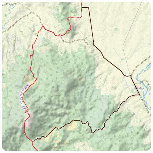
Otautau |
|
|
If you plan to resupply in Otautau this detour will be more like a shortcut. If you follow the Te Araroa, you will have to walk or hitchhike 13km (one-way) to get into town. Taking this little side route, you will be walking into town by skipping that first 13km, and a lot of mud!
Direction: Around km 2888, you will meet a gravel road, if you follow that road heading down, it will ultimately lead you into town. Then from town, you can walk back on the trail and meet it around km 2862. Distance: The official trail is 25km and the detour is 32km. So the detour is longer by about 7km. |
|
|
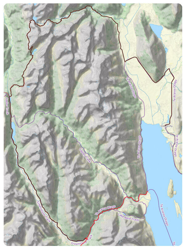
Routeburn Track |
|
|
In May 2005, the Routeburn Track was named one of the top eleven trails in the world by National Geographic Magazine. It is quite a beautiful trail! Instead of doing this trail as a side trip why not include it into your thru-hike?
Direction: At Greenstone Hut (km 2691) you will cross a bridge, the TA will be heading on the right (North-East), instead turn left (heading West). You will be on the Greenstone Track follow that to Lake Howden Hut. At the Hut, you will meet the Routeburn Track. From there it is very straight forward to Routeburn Road. The Routeburn Road leads you to Glenorchy where you can resupply and do the next detour below or hitch to Queenstown. Distance: The official trail goes 13km before reaching the lake. The detour is 77km. Side note: You are not allowed to freedom camp on the Routeburn Track, you will either have to pay for hut and campground or do it in a day. |
|
|
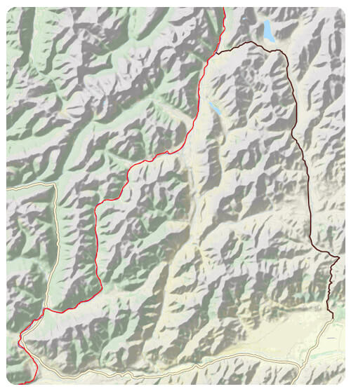
Rees Track and Cascade Saddle |
|
Less known and established than the Routeburn Track, I found this one equally beautiful. Rees Glacier and Cascade Saddle will make your jaw drop I promise!

|
Direction: From Glenorchy, follow Glenorchy Paradise Road then Rees Valley Road (before the bridge). Rees Track starts at the end of the road. The trail is straight forward until Dart Hut. At the Hut, you will have to leave the track for a less marked route heading towards Rees Glacier. That Route goes to Aspiring Hut where you will meet the West Matukituki Track which leads you to Wanaka Mount Aspiring Road. That goes (as the name says) to Wanaka.
Distance: From Queenstown to the meeting point it's 72km. For the detour, the distance from Glenorchy to the meeting point is 111km. Side note: Cascade Saddle to Aspiring Hut is a steep descent. It is ranked among some of the most dangerous trails in the world (no joke!). Its steepness might not seem so deadly, but don't be here on icy conditions. Make sure you know the conditions you will be facing. |
|
|
Hanmer Springs |
|
|
If you plan to resupply in Hanmer Springs (I would recommend it, they have hot springs with slides!) this will save you some hitchhiking time. That shortcut will allow you to hitch one way only.
Direction: From Hanmer Springs follow the Clarence Valley Road up Jack Pass, then, Tophouse Road. Along that road, you have a few trails heading west towards the TA. Take the one you want. I personally pushed it to Lake Tennyson and followed the St James Cycle Trail into the valley and crossed the Waiau Uwna River to the TA. Distance: From the highway to the meet point with the TA is 57km long. The detour is 50km from Hanmer Springs. Side note: I have heard there is a wild hot spring close to Scotties Hut, more precisely up Cow Stream. If that is the way you are taking, it might be worth extra research. |


|
If you want to help me out.
Support this website |
Any questions or comments?
Contact me |
Treks Travels Thoughts is uncopyrighted